|
Eastern Walkway - Te Ara Mātaratara
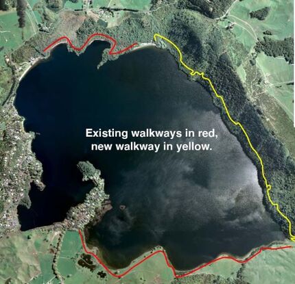
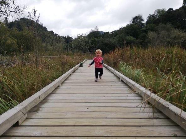
Following resource consent in October 2021 and extensive community consultation, LOCA have announced the subsequent build of the track to get underway in spring/summer. The construction of the new track across the Lake Ōkāreka Scenic Reserve and Playnes Farm will improve recreational access for local residents, enhance the experience for fee paying guests in the community managed campgrounds. At present there are two key walkways: One from Boyes Beach to DOC Campground and the other from Acacia Road to the Tarawera outlet along the boardwalk. The linking track of approx 3.8km has been designed to be a low profile family friendly walk with a gentle gradient which would be a total round-the-lake walk of just over 10km. |
FAQ
Will I see the walkway from the settlement?
The entire walkway length will be under canopy about one third to a half of the way up the eastern slope without lakeside access until the outlet. It will be of lower profile and with (BackCountry Comfort Seeker) than the existing tracks and avoid tree removal. As the canopy will not be changed, it is not expected that the walkway will be visible.
Will it generate erosion and slips?
From aerial photography history, this slope has been cleared by the Tarawera Eruption, revegetated with bush canopy and with no slips on the subject area. A detailed geotechnical assessment has been undertaken by HDGeo resulting in minor changes to track alignment to avoid some potential erosion prone areas. Track construction will involve a “Construction Management Plan” with methods to avoid any overladen discharge of solids. The design will incorporate features such as bridges, culverts, retaining and clean water diversions as appropriate. Designing a track well, first time, will reduce future maintenance costs and any erosion.
The width of the track has been significantly reduced over time to a target of 850mm.
Why do we need to build a bridge?
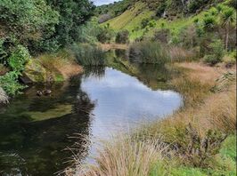
A crossing used to exist over the outlet. However, this has been removed by Bay of Plenty Regional Council in response to lake flooding events. A resource consent is not required for this bridge. A pole bridge of sufficient span has been costed between $20k to $30k including design and building consent. Materials and labour we will aim to gain local support for.
Who owns the land?
Department of Conservation administer the majority of the land in the Lake Ōkāreka Scenic Reserve and the rest of the trail to the south traverses the Playne Family Farm - who have granted permission for this track by way of long-term license.
Wasn’t there a different route earlier?
Yes. A past proposal was to build a hiking trail on the ridgeline. The LŌCA committee since has unanimously accepted the new design as it is of easier grade and less distance (making it more family friendly), it holds resource consent, has affected party approval (including neighbours) and provides more opportunity for future recreational and trapping access.
What do mana whenua think?
Support from both Tuhourangi and Raukawa were gained in the consent process. With Tuhourangi as mana whenua, a Cultural Impact Assessment was undertaken which both helped with the understanding of the project, historic context and identified features on the ridgeline to avoid - including the site of an urupa on the previously suggested route. We will continue to involve mana whenua in the future of the track.
Does the track have a name?
It is simply known as the Eastern Walkway for now due to aspect. The entire loop length could be named rather than just this section.
Tuhourangi have suggested use of the name - Te Ara Mātaratara for this section of walkway. This links with the story of the death of the taniwha Kataore and subsequent declaration of war from Chief Tangaroamihi.
How much will it cost?
Initial estimates for the track alone were about $100,000. It is anticipated to be higher given inflation, appointing a project manager and some additional design work, including a bridge over the outlet. DoC have provided design and costings for a similar bridge engineered and built at $30,000.
Most costs to date have kindly been covered either pro-bono or by the Walking Access Commission Enhanced Access Grant, with some community contribution from operation of the campgrounds. Rotorua Trust have also committed to contribution of $75,000 for the track build. More investment is incoming to assist with the predator trapping and pest management of possums and wallabies along the Scenic Reserve.
The campground has required significant investment, in excess of income. This has been related to COVID shortfall in tourism It is anticipated that all future DoC Reserve maintenance costs will be covered by campground income.
How many people will it employ?
Construction is anticipated to take a project manager and 4 staff approximately 60 days to complete with hand tools. Rotorua already has some of the world's best trail builders experienced in local conditions. There is no restriction on what season to build this as it is under cover.
What are the effects on the bush?
Track construction will require the disturbance of soil and removal of vegetation. With minimal tree removal proposed in forming the track, the biggest effects will be the incursion of pests along a track. The existing area is already prone to wallaby browsing and having better access will help in better controlling populations. On the balance, the track will be better for managing these pests - particularly in establishing new trapping lines, moving towards the long term vision of LOCA to turn this area into a Predator Free Sanctuary.
To mitigate and plant pest incursion, any equipment will be steam cleaned prior to arrival and pest management in the form of existing baiting and trapping lines will help manage populations.
Will there be more parking?
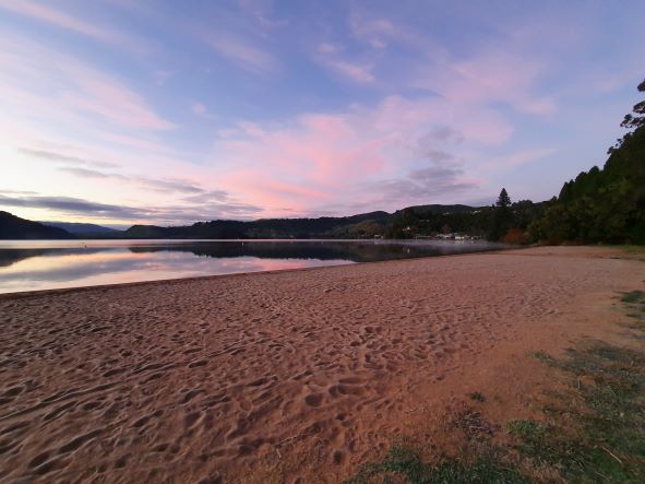
No further parking is currently planned with users directed to existing facilities - i.e. Boyes Beach, DoC Campground and Acacia Rd. With a loop track, parking can be more distributed among existing lake assets. Boyes Beach is to be the intended trailhead.
Will there be more visitors?
There will be more visitors that enjoy walking longer distances of approx. 10-11km. Lake Ōkāreka currently receives a large volume of summer visitors to the lake as a recreation attraction. This is unlikely to change the nature of those visitors, nor their numbers. Think about the type of people who like to take long walks and their general behaviour.
How will this help the community?
More recreational access - particularly middle distance and family friendly, increase the desirability for campers to use the available facilities. More fee paying campers generate more revenue for community pest management projects and activities. It is also hoped that such guests and more eyes will help reduce some issues of vandalism and antisocial behaviour experienced when camp numbers are low (off-season). Potential for more excercise and leisure options for residents and guests is a bonus too.
Who are you working with?
So far, we have worked with affected parties, landowners (including DoC) and mana whenua in forming the track design and permissions, as well as both Rotorua Lakes Council and Bay of Plenty Regional. Specialist ecologists, geotechnical experts, track builders and cultural impacts assessors have been engaged.
Will I see the walkway from the settlement?
The entire walkway length will be under canopy about one third to a half of the way up the eastern slope without lakeside access until the outlet. It will be of lower profile and with (BackCountry Comfort Seeker) than the existing tracks and avoid tree removal. As the canopy will not be changed, it is not expected that the walkway will be visible.
Will it generate erosion and slips?
From aerial photography history, this slope has been cleared by the Tarawera Eruption, revegetated with bush canopy and with no slips on the subject area. A detailed geotechnical assessment has been undertaken by HDGeo resulting in minor changes to track alignment to avoid some potential erosion prone areas. Track construction will involve a “Construction Management Plan” with methods to avoid any overladen discharge of solids. The design will incorporate features such as bridges, culverts, retaining and clean water diversions as appropriate. Designing a track well, first time, will reduce future maintenance costs and any erosion.
The width of the track has been significantly reduced over time to a target of 850mm.
Why do we need to build a bridge?
A crossing used to exist over the outlet. However, this has been removed by Bay of Plenty Regional Council in response to lake flooding events. A resource consent is not required for this bridge. A pole bridge of sufficient span has been costed between $20k to $30k including design and building consent. Materials and labour we will aim to gain local support for.
Who owns the land?
Department of Conservation administer the majority of the land in the Lake Ōkāreka Scenic Reserve and the rest of the trail to the south traverses the Playne Family Farm - who have granted permission for this track by way of long-term license.
Wasn’t there a different route earlier?
Yes. A past proposal was to build a hiking trail on the ridgeline. The LŌCA committee since has unanimously accepted the new design as it is of easier grade and less distance (making it more family friendly), it holds resource consent, has affected party approval (including neighbours) and provides more opportunity for future recreational and trapping access.
What do mana whenua think?
Support from both Tuhourangi and Raukawa were gained in the consent process. With Tuhourangi as mana whenua, a Cultural Impact Assessment was undertaken which both helped with the understanding of the project, historic context and identified features on the ridgeline to avoid - including the site of an urupa on the previously suggested route. We will continue to involve mana whenua in the future of the track.
Does the track have a name?
It is simply known as the Eastern Walkway for now due to aspect. The entire loop length could be named rather than just this section.
Tuhourangi have suggested use of the name - Te Ara Mātaratara for this section of walkway. This links with the story of the death of the taniwha Kataore and subsequent declaration of war from Chief Tangaroamihi.
How much will it cost?
Initial estimates for the track alone were about $100,000. It is anticipated to be higher given inflation, appointing a project manager and some additional design work, including a bridge over the outlet. DoC have provided design and costings for a similar bridge engineered and built at $30,000.
Most costs to date have kindly been covered either pro-bono or by the Walking Access Commission Enhanced Access Grant, with some community contribution from operation of the campgrounds. Rotorua Trust have also committed to contribution of $75,000 for the track build. More investment is incoming to assist with the predator trapping and pest management of possums and wallabies along the Scenic Reserve.
The campground has required significant investment, in excess of income. This has been related to COVID shortfall in tourism It is anticipated that all future DoC Reserve maintenance costs will be covered by campground income.
How many people will it employ?
Construction is anticipated to take a project manager and 4 staff approximately 60 days to complete with hand tools. Rotorua already has some of the world's best trail builders experienced in local conditions. There is no restriction on what season to build this as it is under cover.
What are the effects on the bush?
Track construction will require the disturbance of soil and removal of vegetation. With minimal tree removal proposed in forming the track, the biggest effects will be the incursion of pests along a track. The existing area is already prone to wallaby browsing and having better access will help in better controlling populations. On the balance, the track will be better for managing these pests - particularly in establishing new trapping lines, moving towards the long term vision of LOCA to turn this area into a Predator Free Sanctuary.
To mitigate and plant pest incursion, any equipment will be steam cleaned prior to arrival and pest management in the form of existing baiting and trapping lines will help manage populations.
Will there be more parking?
No further parking is currently planned with users directed to existing facilities - i.e. Boyes Beach, DoC Campground and Acacia Rd. With a loop track, parking can be more distributed among existing lake assets. Boyes Beach is to be the intended trailhead.
Will there be more visitors?
There will be more visitors that enjoy walking longer distances of approx. 10-11km. Lake Ōkāreka currently receives a large volume of summer visitors to the lake as a recreation attraction. This is unlikely to change the nature of those visitors, nor their numbers. Think about the type of people who like to take long walks and their general behaviour.
How will this help the community?
More recreational access - particularly middle distance and family friendly, increase the desirability for campers to use the available facilities. More fee paying campers generate more revenue for community pest management projects and activities. It is also hoped that such guests and more eyes will help reduce some issues of vandalism and antisocial behaviour experienced when camp numbers are low (off-season). Potential for more excercise and leisure options for residents and guests is a bonus too.
Who are you working with?
So far, we have worked with affected parties, landowners (including DoC) and mana whenua in forming the track design and permissions, as well as both Rotorua Lakes Council and Bay of Plenty Regional. Specialist ecologists, geotechnical experts, track builders and cultural impacts assessors have been engaged.
